
Official Belgian data, explained
Cumulative confirmed COVID-19 cases (archived) by municipality in Belgium (2023-10-03)
This page maps Cumulative confirmed COVID-19 cases (archived) for one nationally comparable 2023-10-03 slice. Every figure below uses the same disclosed definition, unit, geography and source.
Health
What this indicator measures
Archived cumulative COVID-19 case export; it is not a current-incidence measure and must not be compared as a live ranking.
Indicator dossier
Data passport
- Selected reference period
- 2023-10-03
- Geography
- municipalities
- Boundary set
- Statistical sectors 2023
- Measure
- Cumulative confirmed COVID-19 cases (archived)
- Unit
- cases
- Comparable areas
- 581
- Coverage
- 100%
Indicator dossier
Selected slice
Exact catalogue filters applied to the map, statistics and comparison.
- Publication status
- Published value
Latest published slice
How to read the pattern
- Median
- 5,218cases
- Unweighted area mean
- 8,184cases
- Minimum
- 27cases
- Maximum
- 218,191cases
Across the valid national comparison set, the median is 5,218 cases. Values extend from 27 to 218,191 cases. This describes geographic variation; it is not a score of local quality.
Geography
Map of Belgium
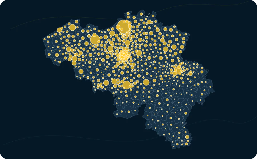
- 218,191circle area
- 5,218circle area
- 3,111circle area
Areas
Value distribution
| Value | Areas |
|---|---|
| 27–9,117 | 441 |
| 9,117–18,207 | 101 |
| 18,207–27,298 | 17 |
| 27,298–36,388 | 9 |
| 36,388–45,478 | 5 |
| 45,478–54,568 | 2 |
| 54,568–63,658 | 1 |
| 63,658–72,748 | 1 |
| 72,748–81,839 | 2 |
| 81,839–90,929 | 0 |
| 90,929–100,019 | 0 |
| 100,019–109,109 | 0 |
| 109,109–118,199 | 1 |
| 118,199–127,289 | 0 |
| 127,289–136,380 | 0 |
| 136,380–145,470 | 0 |
| 145,470–154,560 | 0 |
| 154,560–163,650 | 0 |
| 163,650–172,740 | 0 |
| 172,740–181,830 | 0 |
| 181,830–190,921 | 0 |
| 190,921–200,011 | 0 |
| 200,011–209,101 | 0 |
| 209,101–218,191 | 1 |
Explore this exact slice in the atlas Download this data as CSV
municipalities
Highest and lowest values
From 581 comparable areas, the table shows a concise descriptive high-and-low sample. Equal values do not imply equal local circumstances.
| Highest | 1 | Antwerpen | 11002 | 218,191 cases |
|---|---|---|---|---|
| Highest | 2 | Gent | 44021 | 112,698 cases |
| Highest | 3 | Charleroi | 52011 | 77,490 cases |
| Highest | 4 | Bruxelles | 21004 | 74,853 cases |
| Highest | 5 | Liège | 62063 | 72,118 cases |
| Highest | 6 | Schaerbeek | 21015 | 55,494 cases |
| Highest | 7 | Anderlecht | 21001 | 48,668 cases |
| Highest | 8 | Brugge | 31005 | 48,605 cases |
| Highest | 9 | Namur | 92094 | 44,617 cases |
| Highest | 10 | Leuven | 24062 | 40,096 cases |
| Lowest | 581 | Herstappe | 73028 | 27 cases |
| Lowest | 580 | Mesen | 33016 | 379 cases |
| Lowest | 579 | Daverdisse | 84016 | 533 cases |
| Lowest | 578 | Horebeke | 45062 | 787 cases |
| Lowest | 577 | Bever | 23009 | 809 cases |
| Lowest | 576 | Herbeumont | 84029 | 812 cases |
| Lowest | 575 | Rendeux | 83044 | 893 cases |
| Lowest | 574 | Spiere-Helkijn | 34043 | 897 cases |
| Lowest | 573 | Rouvroy | 85047 | 912 cases |
| Lowest | 572 | Martelange | 81013 | 952 cases |
Method and limitations
Method and limitations
No missing value is imputed. Where colour classes are used, their breaks and colours come from the catalogue; source-declared suppression remains missing.
The area mean gives every published geographic area equal weight. It is not weighted by population, exposure or area size.
Archived cumulative COVID-19 case export; it is not a current-incidence measure and must not be compared as a live ranking.
Source-native municipality observations; no higher-grain value is assigned to a lower geography.
Read the methodologySources, licence and provenance
Sources, licence and provenance
- Source
- Sciensano
- Reuse terms
- Public source; explicit reuse terms were not stated by the publisher.
- Licence
- CC BY 4.0