
Population density of Charleroi
Reference date: 2026-01-01
2,009.8
residents/km²
Charleroi recorded 2,009.8 residents per km² in 2026, ranking 32nd among Belgium's municipalities by population density.


- Population
- 206,900residents
- Rank in Belgium
- 32ndout of 565 municipalities
- Density change
- +11.0
- Reference date
- 2026-01-01
Population density
Inside the municipality
Population is unevenly distributed. The view below uses exact 2025 statistical-sector boundaries and never assigns residents to an unknown polygon.99.9% of residents are located to a statistical sector; 114 remain available only in the municipality total.
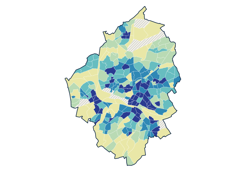
- 0 residents
- 1.6–945.0 residents/km²
- 979.9–2,000.3 residents/km²
- 2,022.6–3,221.8 residents/km²
- 3,223.6–4,435.7 residents/km²
- 4,525.4–13,568.2 residents/km²
View the exact data table
| CHARLEROI - VILLE HAUTE 52011A00K | 2,733 | 13,568.2 residents/km² |
|---|---|---|
| UNIVERSITE DU TRAVAIL 52011A04K | 1,747 | 12,668.3 residents/km² |
| CALVAIRE 52011P01- | 1,587 | 9,942.1 residents/km² |
| L'ALOUETTE 52011A333 | 1,463 | 9,465.5 residents/km² |
| ALLEE VERTE 52011N13L | 466 | 9,221.1 residents/km² |
Official time series
Source: official Statbel data · Statbel
View the exact data table
| 2026 | 206,900 | 2,009.8 |
| 2025 | 205,763 | 1,998.7 |
| 2024 | 204,322 | 1,984.7 |
| 2023 | 203,785 | 1,979.5 |
| 2022 | 202,421 | 1,966.3 |
| 2021 | 201,837 | 1,960.6 |
| 2020 | 202,746 | 1,969.4 |
| 2019 | 202,267 | 1,964.7 |
| 2018 | 201,816 | 1,960.4 |
| 2017 | 201,256 | 1,953.8 |
| 2016 | 202,182 | 1,962.8 |
| 2015 | 202,480 | 1,965.6 |
| 2014 | 202,730 | 1,968.1 |
| 2013 | 203,753 | 1,978.0 |
| 2012 | 203,871 | 1,979.1 |
| 2011 | 203,467 | 1,975.2 |
| 2010 | 202,598 | 1,966.8 |
| 2009 | 202,234 | 1,963.3 |
Key figures
Use these population patterns in Horizon Mapper for catchment and location-opportunity analysis. Horizon Mapper