
Population density of Chaudfontaine
Reference date: 2026-01-01
806.3
residents/km²
Chaudfontaine recorded 806.3 residents per km² in 2026, ranking 101st among Belgium's municipalities by population density.


- Population
- 20,525residents
- Rank in Belgium
- 101stout of 565 municipalities
- Density change
- +0.1
- Reference date
- 2026-01-01
Population density
Inside the municipality
Population is unevenly distributed. The view below uses exact 2025 statistical-sector boundaries and never assigns residents to an unknown polygon.100.0% of residents are located to a statistical sector; 3 remain available only in the municipality total.
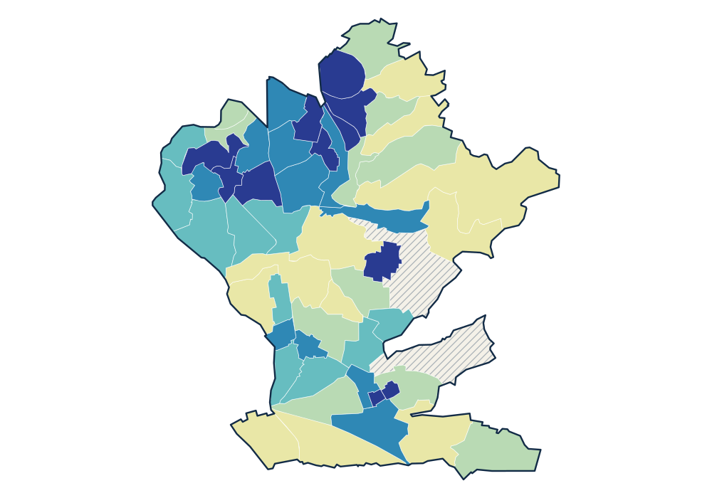
- 0 residents
- 22.3–427.4 residents/km²
- 436.2–727.9 residents/km²
- 797.2–1,212.5 residents/km²
- 1,266.1–1,756.3 residents/km²
- 1,890.5–4,147.8 residents/km²
View the exact data table
| VAUX-SOUS-CHEVREMONT-CENTRE 62022D00- | 1,268 | 4,147.8 residents/km² |
|---|---|---|
| CLOS PERLY 62022B01K | 153 | 3,468.1 residents/km² |
| BECHURON - RANSY 62022D01- | 1,400 | 3,216.0 residents/km² |
| EMBOURG-CENTRE 62022C00K | 486 | 2,970.3 residents/km² |
| AU TIEGE 62022B01L | 133 | 2,445.3 residents/km² |
Official time series
Source: official Statbel data · Statbel
View the exact data table
| 2026 | 20,525 | 806.3 |
| 2025 | 20,523 | 806.2 |
| 2024 | 20,600 | 809.2 |
| 2023 | 20,572 | 808.1 |
| 2022 | 20,556 | 807.5 |
| 2021 | 20,807 | 817.3 |
| 2020 | 20,855 | 819.2 |
| 2019 | 20,800 | 817.8 |
| 2018 | 20,935 | 823.1 |
| 2017 | 20,885 | 817.7 |
| 2016 | 20,766 | 813.1 |
| 2015 | 21,001 | 822.3 |
| 2014 | 21,047 | 824.1 |
| 2013 | 21,059 | 824.5 |
| 2012 | 20,944 | 820.0 |
| 2011 | 20,940 | 819.9 |
| 2010 | 20,865 | 816.9 |
| 2009 | 20,904 | 818.5 |
Key figures
Use these population patterns in Horizon Mapper for catchment and location-opportunity analysis. Horizon Mapper