
Official Belgian data, explained
Black carbon — Annual mean by municipality in Belgium (2024)
This page maps Black carbon — Annual mean for one nationally comparable 2024 slice. Every figure below uses the same disclosed definition, unit, geography and source.
Environment
What this indicator measures
Calendar-year mean of IRCEL-CELINE's daily population-weighted Black carbon municipality concentration.
Indicator dossier
Data passport
- Selected reference period
- 2024
- Geography
- municipalities
- Boundary set
- Statistical sectors 2019
- Measure
- Annual mean
- Unit
- µg/m³
- Comparable areas
- 581
- Coverage
- 100%
Latest published slice
How to read the pattern
- Median
- 0.39µg/m³
- Unweighted area mean
- 0.39µg/m³
- Minimum
- 0.14µg/m³
- Maximum
- 0.76µg/m³
Across the valid national comparison set, the median is 0.39 µg/m³. Values extend from 0.14 to 0.76 µg/m³. This describes geographic variation; it is not a score of local quality.
Geography
Map of Belgium
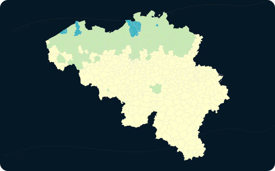
- 0.12–0.46376 areas
- 0.46–0.65192 areas
- 0.65–0.8713 areas
- 0.87–1.190 areas
- 1.19–3.530 areas
Areas
Value distribution
| Value | Areas |
|---|---|
| 0.14–0.19 | 41 |
| 0.19–0.24 | 57 |
| 0.24–0.28 | 49 |
| 0.28–0.33 | 63 |
| 0.33–0.38 | 54 |
| 0.38–0.43 | 70 |
| 0.43–0.47 | 77 |
| 0.47–0.52 | 65 |
| 0.52–0.57 | 49 |
| 0.57–0.62 | 35 |
| 0.62–0.66 | 12 |
| 0.66–0.71 | 5 |
| 0.71–0.76 | 4 |
Explore this exact slice in the atlas Download this data as CSV
municipalities
Highest and lowest values
From 581 comparable areas, the table shows a concise descriptive high-and-low sample. Equal values do not imply equal local circumstances.
| Highest | 1 | Antwerpen | 11002 | 0.76 µg/m³ |
|---|---|---|---|---|
| Highest | 2 | Zwijndrecht | 11056 | 0.74 µg/m³ |
| Highest | 3 | Stabroek | 11044 | 0.73 µg/m³ |
| Highest | 4 | Borsbeek | 11007 | 0.72 µg/m³ |
| Highest | 5 | Schoten | 11040 | 0.7 µg/m³ |
| Highest | 6 | Oostende | 35013 | 0.69 µg/m³ |
| Highest | 7 | Bredene | 35002 | 0.68 µg/m³ |
| Highest | 8 | Kapellen | 11023 | 0.67 µg/m³ |
| Highest | 8 | Brugge | 31005 | 0.67 µg/m³ |
| Highest | 10 | Brasschaat | 11008 | 0.66 µg/m³ |
| Lowest | 579 | Vresse-sur-Semois | 91143 | 0.14 µg/m³ |
| Lowest | 579 | Daverdisse | 84016 | 0.14 µg/m³ |
| Lowest | 579 | Stoumont | 63075 | 0.14 µg/m³ |
| Lowest | 576 | Herbeumont | 84029 | 0.15 µg/m³ |
| Lowest | 576 | Bouillon | 84010 | 0.15 µg/m³ |
| Lowest | 576 | Manhay | 83055 | 0.15 µg/m³ |
| Lowest | 565 | Gedinne | 91054 | 0.16 µg/m³ |
| Lowest | 565 | Saint-Léger | 85034 | 0.16 µg/m³ |
| Lowest | 565 | Florenville | 85011 | 0.16 µg/m³ |
| Lowest | 565 | Saint-Hubert | 84059 | 0.16 µg/m³ |
Method and limitations
Method and limitations
No missing value is imputed. Where colour classes are used, their breaks and colours come from the catalogue; source-declared suppression remains missing.
The area mean gives every published geographic area equal weight. It is not weighted by population, exposure or area size.
IRCEL-CELINE daily population-weighted RIO 4 x 4 km concentrations, harmonised by the publisher to the municipality status after the 2019 fusion.
Calendar-year mean of daily modelled concentrations.
Read the methodologySources, licence and provenance